Thursday, October 31, 2013

Run 52: Sayler Park


We visited Sayler Park on the kind of fall morning that makes you nostalgic for the moment before it’s even gone: crisp but not too cold, the smell of wood burning stoves, trees ablaze.  

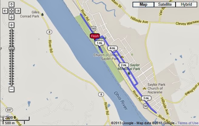
We started our run at the 63-acre Fernbank Park, which stretches along the Ohio River for over a mile.  We made a loop on a meandering jogging path, passing older couples, families, and dog walkers.


Look at this park—it’s gorgeous!  You could make an afternoon of walking along the river path and looking at the foliage.  This is the kind of place to take out-of-town guests or a first date.  


And then, as if the park hadn’t already exceeded all of our expectations, we discovered these well-kept hiking trails through the woods.  Unlike the running trails we’re used to, these weren’t full of trip-hazard roots—just a wide, packed-dirt path.  


At that point, we decided that Fernbank Park is in the running for the best "never seen it before" surprise we have discovered on a Run 52.   Contenders include Fleischman Gardens in Avondale and the reservoir path in California.


We tore ourselves away from Fernbank Park to check out the rest of the neighborhood.  Sayler Park is Cincinnati’s western-most neighborhood and was annexed by the City in 1911.  It is about a 20 minute drive from Downtown, through Sedamsville and then Riverside.  The neighborhood is named after Nelson Sayler, who was an early settler who served as the community’s first Mayor.  Here is a picture of him on the side of this building.  The other gentleman is Doctor Gracely, namesake of Sayler Park’s Gracely Drive. 


Sayler Park is known for its big, beautiful Victorian homes.  Although these survived the infamous Sayler Park tornado of 1974, many others were lost:


Some of the Victorians are featured on the Sayler Park ArtWorks mural, which showcases Sayler Park’s past, present, and future:


In addition to the Victorians, I loved this one-room schoolhouse turned into a single-family house, and this adorable little barber shop:


Nearby, is the Parkland Theatre, where you can still see a movie for just three dollars!


On our loop around Gracely and Parkland, we stopped at two more parks—Stuart Park and the eponymous “Sayler Park”:


Although I snapped this shot because I thought the horse was cute, it also serves to illustrate how tree-lined the Sayler Park streets are:


Although Donnie had never been to Sayler Park before our run, I had been once before to buy litter pick-up sticks from the hardware shop on Gracely Drive.  There is a great little business corridor that includes the hardware store, a boat repair shop, and the Bizy Bees Bakery, which was advertising pumpkin donuts!


Yeah, they had me at “pumpkin.”  Although we were well aware that donuts would cancel out any calories we may have burned on our run, we stopped for a sack of them on our way out of the neighborhood.  The pumpkin donut was like a moist and spicy zucchini bread.  YUMM!


K.


View the full route with mile markers here:  http://www.usatf.org/routes/view.asp?rID=529733 

Tuesday, October 29, 2013

Run 52: Roselawn


Roselawn is similar to its northern counterparts Bond Hill, North Avondale, and Paddock Hills.  Like these other neighborhoods, Roselawn has some residential areas tucked away off of busy Reading Road. Also, like Paddock Hills, Roselawn features a few restaurants throughout its business district. Of course, over-emphasizing these similarities might lead one to believe that there isn’t much unique about Roselawn,  but that isn't the case. We discovered that Roselawn is unique in its own right, starting with the stone entryway into the garden district.


From a running standpoint I noticed that we fell into an easy rhythm as we turned off of Seymour and headed north on Reading. In hindsight, I realize that this is due to the relative lack of cross streets which allowed us to keep moving without having to stop at lights. 

It wasn't long before we arrived at the Roselawn business district. Roselawn's business district is perhaps best known for its array of ethnic restaurants and grocery stores.  Believe it or not, I have made it several times to Amma's Kitchen to enjoy the lunch buffet, which I highly recommend. To my knowledge it's the only South Indian spot in the city.


The district also features two night clubs Nephews and Celebrities. Adding a little techno-tropical flair to the district, Celebrities features some illuminated palm trees.


As soon as we left the business district and entered the residential blocks, it started to pour. At first Kayla appeared to be a bit panicked:


But it didn’t take long for her to pull it together and enjoy the easy running.


Along the way we continued to discover aspects of Roselawn that can't be found anywhere else in the city.  

Where else have we seen a tree like this?


And, where else have we seen a house like this?


Roselawn also features its share of conventional elements--gaslights,tree-lined streets, sidewalks-- which leave no doubt that it is a Cincinnati neighborhood.


Before long we had made our way back to Reading. Just around the corner from our starting place was Roselawn Park. I was looking forward to checking out the park as it is in the process of being developed into the Reds Urban Youth Academy, which will train the next generation of baseball and softball players. Unfortunately, when we got to the park, it was completely shutdown for renovation, so we'll have to make our way back once everything is completed.


We returned home to find that Zola had thrown on her hoodie and was ready to run. 


After we explained to her that she had missed out, she settled for a raincheck and a photo-op with her mother.


You can see our whole route here: http://www.usatf.org/routes/view.asp?rID=528727


Tuesday, October 22, 2013

Run 52: Riverside


The fog had yet to burn off for the day as we drove along US 50 West into Riverside.  Riverside is a long, narrow West Side neighborhood that runs along the Ohio River between Sedamsville and Saylor Park.  Along this stretch 50 West is known as River Road.  The busy four-lane thoroughfare divides the neighborhood.  On the south side of the road, industry and railroad tracks hug the river.  On the north side of the road, houses creep up the hillside.   


We started our run from the Riverside Boat Launch.  The small park also has ball fields, a short walking path, and a carousel-inspired picnic shelter. 


A barge was passing by and we jogged down to the launch to get a closer look:


By the time we left the park, the sun was starting to burn through the fog and we could see the pretty autumn trees along the hillside.  This view is of the Delshire Preserve which is owned and managed by the Western Wildlife Corridor:


We crossed River Road to run on the sidewalk.  Many of the homes built on the hillside have river views:


We came across the Twin Sisters, which are identical houses built in the 1890s by a prominent Cincinnati judge.  The Digging Cincinnati History blog has a great article about the homes, and in reading it I learned that Judge Wright built them for two of his children, one of whom would go on to become the mayor of the Village of Riverside and later, a United States Supreme Court Justice!   


St. Vincent de Paul is also perched along the hillside overlooking the river.  St. Vincent de Paul, known for serving the poor, is Donnie’s favorite Catholic Saint and the namesake of his alma mater.  Donnie sweetly asked me if I wanted to pose with the statute, but I think he was secretly glad that I declined. 


Running with traffic along River Road was just a bit nerve-wracking and we were happy when we got to a part of the street that was set back from the main thoroughfare.  This little section of River Road runs parallel to highway but is separated from it by a grassy lawn.  Here, homeowners had their boats parked along the street—convenient for the short drive to the launch. 


At the end of the street, we found an old building that is home to the Tri-State Grain Inspection Service:


We also found a great community sign that detailed the history of the Riverside community.  We learned that Riverside was annexed by the City in 1896 for its industrial base:


There are residential streets like this one that run up the hill from River Road:


Further up on River Road is the Anderson Ferry, which will take pedestrians and cars across the river to Kentucky for a small fee.  When I worked on the West Side, I would often join my coworkers on Friday evenings at Drew’s on the River, which sits at Anderson Ferry and has a close-up view of the river and the ferry traffic.  We turned around at Maag Street so we didn’t make it all the way to the Ferry.  While on the drive to the boat launch, we did pass Jim & Jacks, another Riverside bar and restaurant:


When we returned to the boat launch, Donnie was feeling some remorse that he had skipped the TQL Urban Race and decided that the next best thing would be to hurdle over a barrier in the parking lot.  I begged him not to take the risk, but he scaled it easily:


View the full route with mile markers here: http://www.usatf.org/routes/view.asp?rID=529293


-K.